Tropical Storm Sally on Wednesday, Sept. 16, 2020 at 5:45 p.m. [NOAA image]
A triple threat of active weather is forecast for the Outer Banks, with multiple systems combining to bring us a wet, windy and wavy weather all the way into early next week.
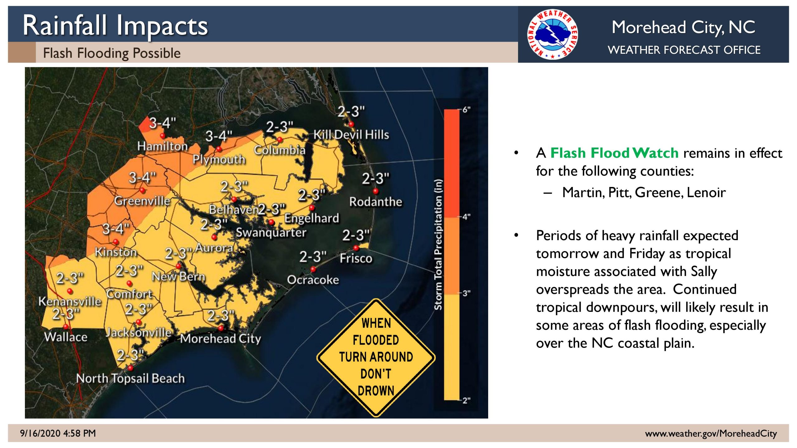
After plodding across the Gulf Coast of Alabama and the Florida Panhandle on Wednesday, the remnants of Hurricane Sally are forecast to bring moderate to heavy rainfall to eastern North Carolina starting Thursday afternoon.
A few thunderstorms could become strong to severe, producing damaging wind gusts with isolated tornadoes possible
A cold front will then pass offshore sweeping out the rest of Sally but stalling offshore, leaving behind strong onshore winds and cooler temperatures.
Coupled with swells from distant Major Hurricane Teddy and higher than normal tides, both will combine to create the potential for beach erosion and overwash into early next week. An elevated rip current risk is also forecast to continue due to the winds and waves.
The front is expected to finally pull away, and it will likely feel like fall of ahead of the Autumnal Equinox on Tuesday.
National Weather Service forecast for Nags Head, as of Wednesday 4:30 p.m.:
Mostly cloudy, with a low around 72. Southeast wind 9 to 11 mph.
A chance of showers, then showers likely and possibly a thunderstorm after 2pm. Cloudy, with a high near 79. Southeast wind 8 to 13 mph. Chance of precipitation is 70%. New rainfall amounts between a quarter and half of an inch possible.
Thursday Night
Showers likely and possibly a thunderstorm, then rain and possibly a thunderstorm after 8pm. Some of the storms could produce heavy rainfall. Low around 74. Southeast wind 10 to 16 mph, with gusts as high as 21 mph. Chance of precipitation is 100%. New rainfall amounts between 1 and 2 inches possible.
Rain likely. Mostly cloudy, with a high near 78. Breezy, with a northwest wind 8 to 13 mph becoming northeast 18 to 23 mph in the afternoon. Winds could gust as high as 30 mph. Chance of precipitation is 70%. New precipitation amounts between three quarters and one inch possible.
Friday Night
A chance of rain. Mostly cloudy, with a low around 69. Windy, with a north wind 26 to 30 mph, with gusts as high as 38 mph. Chance of precipitation is 50%. New precipitation amounts between a tenth and quarter of an inch possible.
A chance of rain. Mostly cloudy, with a high near 74. Windy. Chance of precipitation is 30%. New precipitation amounts of less than a tenth of an inch possible.


Be the first to comment