SnOBX? Significant winter storm to hit eastern N.C., northern Outer Banks might get snow
January 19, 2022OBX TodayComments Off on SnOBX? Significant winter storm to hit eastern N.C., northern Outer Banks might get snow
NWS Weather Prediction Center graphic of the possible severity of the upcoming winter storm as of Wednesday 4 p.m.
A significant winter storm is going to impact all of eastern North Carolina starting late Thursday, and at least part of the Outer Banks may very well get accumulating snow before the system departs on Saturday.
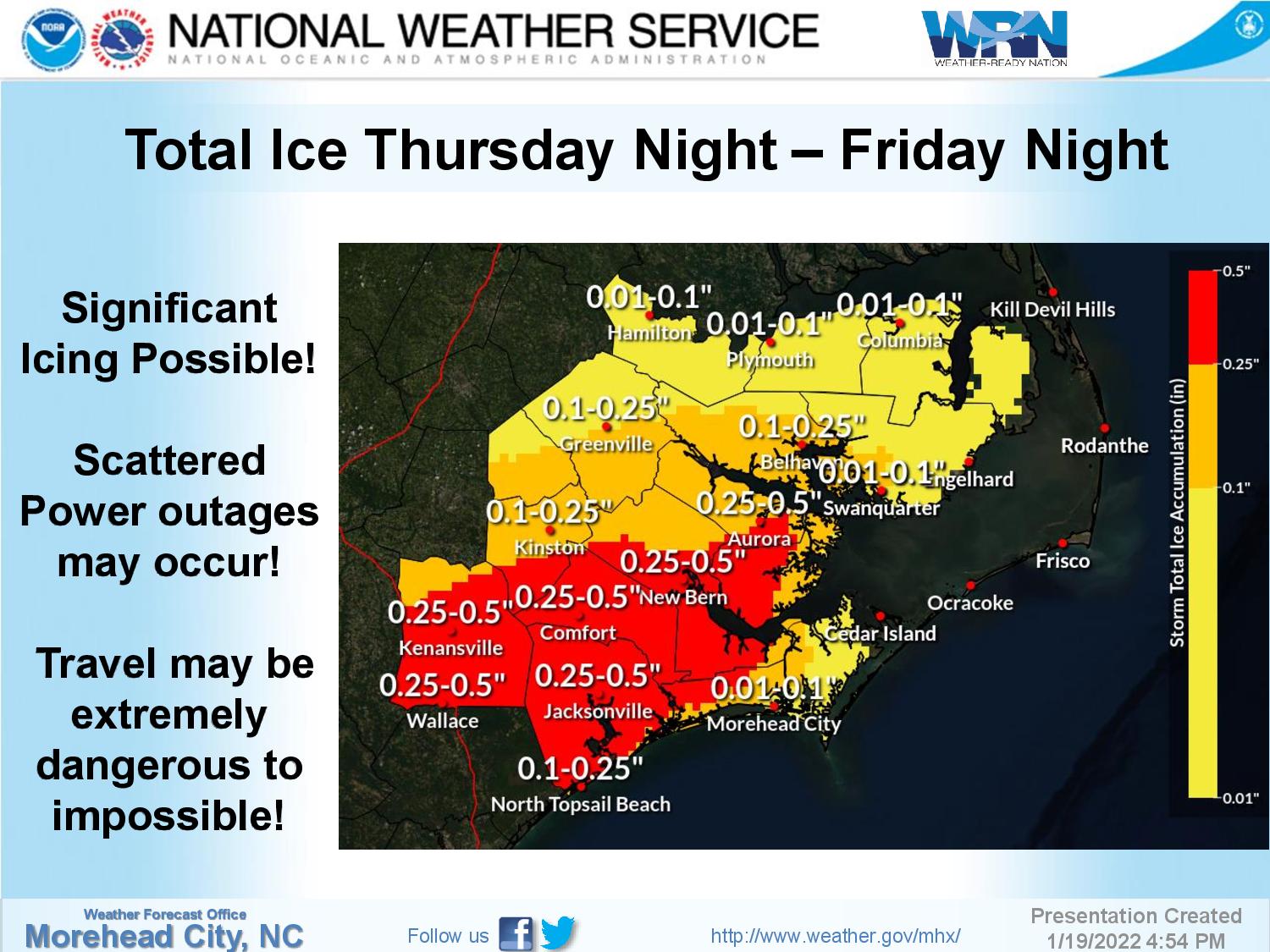
Precipitation will start over the entire area as rain late Thursday from north to south, changing to a wintry mix and then possibly all snow into the overnight hours north of the Albemarle Sound.
There will be a break in the precipitation before it resumes later Friday as a mix of ran, freezing rain, sleet and snow over inland sections, then a shift to all snow for everyone except Hatteras and Ocracoke islands by Saturday morning.
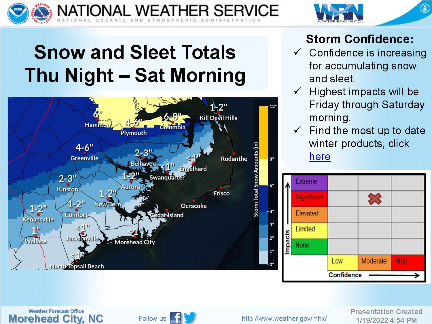
Snowfall will range from just a coating to four inches south of the Albemarle Sound, but some areas along and north of the Albemarle Sound could get up to 8 inches of snow. That depends on how long it takes for the change over to take place.
On the northern beaches, 1 to 4 inches is possible, with how much increasing as you go from south to north.
There could be some minor soundside flooding along southern Hatteras and Ocracoke Friday night into Saturday with strong northerly winds.
A Winter Storm Watch is in effect for the entire region, excluding the Outer Banks.
Once the storm passes, temperatures are forecast to drop into the upper teens to low 20s inland and below freezing along the northern beaches, which means likely refreezing into Sunday morning.
Stay with the OBX Today Weather Center, Beach 104, Big 94.5 WCMS, 99.1 The Sound and Z 92.3 for all the latest info.
National Weather Service forecast for Nags Head, as of Wednesday evening:
Increasing clouds, with a low around 47. Southwest wind 8 to 10 mph, with gusts as high as 15 mph.
A chance of rain, mainly after 5pm. Mostly cloudy, with a high near 56. Breezy, with a southwest wind 9 to 14 mph becoming north 17 to 22 mph in the afternoon. Winds could gust as high as 30 mph. Chance of precipitation is 30%. New precipitation amounts of less than a tenth of an inch possible.
Thursday Night
Rain or freezing rain before 4am, then a chance of freezing rain between 4am and 5am, then a chance of freezing rain and sleet after 5am. Low around 32. Windy, with a north wind 24 to 26 mph, with gusts as high as 37 mph. Chance of precipitation is 80%. Little or no sleet accumulation expected.
Sleet likely before 9am, then rain and sleet. High near 34. Windy, with a north wind 25 to 30 mph, with gusts as high as 41 mph. Chance of precipitation is 80%. New precipitation amounts between a half and three quarters of an inch possible.
Friday Night
Rain and sleet before 10pm, then rain, snow, and sleet between 10pm and 1am, then rain and snow after 1am. Low around 32. Windy, with a north wind 29 to 31 mph, with gusts as high as 43 mph. Chance of precipitation is 90%. New precipitation amounts between a half and three quarters of an inch possible.
Rain and snow likely, mainly before 1pm. Mostly cloudy, with a high near 36. Windy. Chance of precipitation is 60%. New precipitation amounts between a tenth and quarter of an inch possible.
Saturday Night
Partly cloudy, with a low around 29.
Mostly sunny, with a high near 42.
Sunday Night
Partly cloudy, with a low around 31.
Sunny, with a high near 43.
Monday Night
Partly cloudy, with a low around 34.
Partly sunny, with a high near 49.
Tuesday Night
A chance of rain. Mostly cloudy, with a low around 36. Chance of precipitation is 40%.
A chance of rain. Partly sunny, with a high near 46. Breezy. Chance of precipitation is 30%.