Minor soundside flooding overnight and early Friday with strong westerly winds
January 6, 2022OBX TodayComments Off on Minor soundside flooding overnight and early Friday with strong westerly winds
[File photo courtesy Mike Leech Photography]
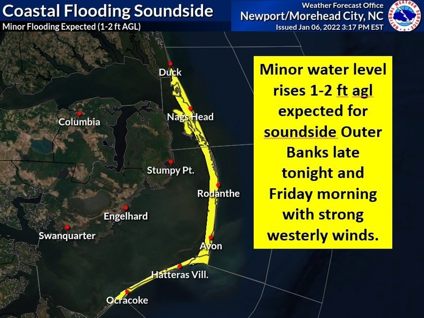
Minor flooding is possible into Friday morning along the soundside as westerly winds pick-up overnight as a cold front crosses the Outer Banks.
Sustained winds out of the west of 15 to 20 mph, with gusts to 25, are expected after midnight and continue until Friday morning, when they will shift to the northwest and increase to 25 to 30 mph before starting to decrease in the afternoon.
According to a coastal flood statement from the Newport/Morehead City office of the National Weather Service, water levels rises of up to two feet above ground are possible.
That will likely lead to standing water in low-lying areas adjacent to the sounds from Duck to Ocracoke, including the typical trouble spots along N.C. 12 on Hatteras Island, as well as Colington Road and other streets and roads normally prone to soundside flooding.
A gale warning has been posted for the Albemarle and Pamlico sounds for Friday from 2 a.m. to noon.
After the cold front moves through tonight high pressure returns for the weekend. Another strong cold front will move through Sunday night and early Monday, which will bring in an Arctic airmass with temperatures well below normal.
National Weather Service forecast for Nags Head, as of Thursday 6 p.m.:
A chance of showers, mainly between 7pm and 3am. Mostly cloudy, with a low around 39. Breezy, with an east wind 6 to 11 mph becoming west 15 to 20 mph after midnight. Winds could gust as high as 24 mph. Chance of precipitation is 30%. New precipitation amounts of less than a tenth of an inch possible.
Mostly cloudy, then gradually becoming sunny, with a high near 40. Windy, with a northwest wind 24 to 29 mph decreasing to 17 to 22 mph in the afternoon. Winds could gust as high as 36 mph.
Friday Night
Mostly clear, with a low around 31. Blustery, with a northwest wind 17 to 20 mph, with gusts as high as 25 mph.
Sunny, with a high near 41. North wind 8 to 18 mph, with gusts as high as 24 mph.
Saturday Night
Mostly clear, with a low around 36. East wind 5 to 7 mph becoming south after midnight.
Mostly sunny, with a high near 62.
Sunday Night
Showers. Low around 43. Breezy. Chance of precipitation is 90%.
A chance of showers before 1pm. Partly sunny, with a high near 48. Windy. Chance of precipitation is 40%.