

Hatteras and Ocracoke islands saw significant ocean overwash flooding Sunday, but the National Weather Service says the worst is yet to come.

Oceanside impacts north of Cape Hatteras, and soundside impacts along the southern Pamlico Sound including Ocracoke Island and the Core Banks, are expected to continue through Monday.
Water levels will be peaking during the high tide cycle late Monday morning to early afternoon, the NWS Newport/Morehead City forecast office said Sunday afternoon.
The Diamond Shoals buoy recorded 14.8’ wave heights Sunday afternoon, and N.C. 12 from Oregon Inlet to Rodanthe remained closed to traffic most of the day.

The Diamond Shoals buoy has recorded 14.8’ wave heights.
Posted by Cape Hatteras National Seashore on Sunday, September 20, 2020
A coastal flood warning remains in effect for the Northern Outer Banks and Hatteras Island, along with high surf advisories. High astronomical tides will bring the threat for minor to moderate coastal flooding around the time of each high tide into early next week, peaking during the high tide around noon Monday, the weather service said.
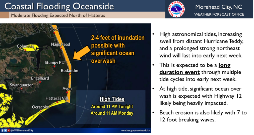
Stronger winds through Monday could bring more extensive coastal flooding impacts, especially for oceanside areas north of Cape Hatteras. And strong, long period swell from distant Hurricane Teddy will affect the coast through early next week, bringing an increased potential for significant beach erosion and dune overwash.
Winds begin to subside late Monday, along with the most significant coastal flooding impacts. Rip current risk will remain elevated through the beginning to middle of next week.
This story originally appeared on OBXToday.com. Read More local stories here.
Be the first to comment