

The United States Coast Guard has sent a survey by mail to local residents about the proposed toll bridge between Currituck County’s mainland and Outer Banks that is currently facing a legal challenge.

Most of the surveys were received Monday by residents of Currituck and Dare counties, and appear to have been addressed to those who have North Carolina fishing and/or hunting licenses.
That included children and infants who have lifetime permits purchased as gifts by their parents, according to an informal poll taken Monday night on Facebook.
The North Carolina Department of Transportation has proposed a 4.7-mile-long, two-lane toll bridge that would run from the Narrow Shore neighborhood north of Aydlett on the Currituck mainland, to an area south of Whalehead Bay and Great Ocean Pond near the Corolla Bay neighborhood.
To connect the main span to U.S. 158 south of Coinjock, a smaller bridge would be built through Great Swamp. The total price tag of the bridge has been estimated NCDOT and N.C. Turnpike Authority at around $400 million.

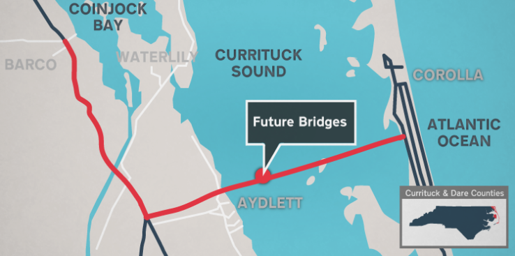
Map depicting the proposed path of the project. [NCDOT]A bridge between the mainland and Corolla has been discussed for nearly four decades. The NCDOT and state officials announced last spring that construction would start this decade.
The Federal Highway Administration gave its initial support for the project to move forward in March 2019. That spurred a lawsuit filed by the Southern Environmental Law Center on behalf of wildlife advocates and a local opposition group.
According to the NCDOT bridge project website, design and development of permit applications is expected some time this spring.
Financing for the project would be complete the following spring, and construction could begin in the spring of 2022.
The survey asks for information from anyone who has has operated a boat in the Currituck Sound between Aydlett and Corolla, including the size and type of boat, the number of trips taken through the area and whether they were recreational or commercial in nature.
Comments are also being sought on a proposed minimum 15-foot vertical and 40-foot horizontal clearance between spans of the fixed bridge, along with bridge protection devices, clearance gauges and navigational lighting.
The section of the sound is used mostly by only small vessels. Water depths are relatively shallow, with the deepest water only around 8 feet, and there are no marked or maintained channels.
According to the Coast Guard’s letter attached to the survey, a marked navigation area would be provided over the deepest water.
The Atlantic Intracoastal Waterway leaves the Currituck Sound about 12 miles north of the proposed path of the bridge, which would not impact vessels that require larger clearances and deeper water.
The deadline to return the survey by mail to the Coast Guard is March 24.
Related links:
This story originally appeared on OBXToday.com. Read More local stories here.
Be the first to comment